Summary of Project Proposal
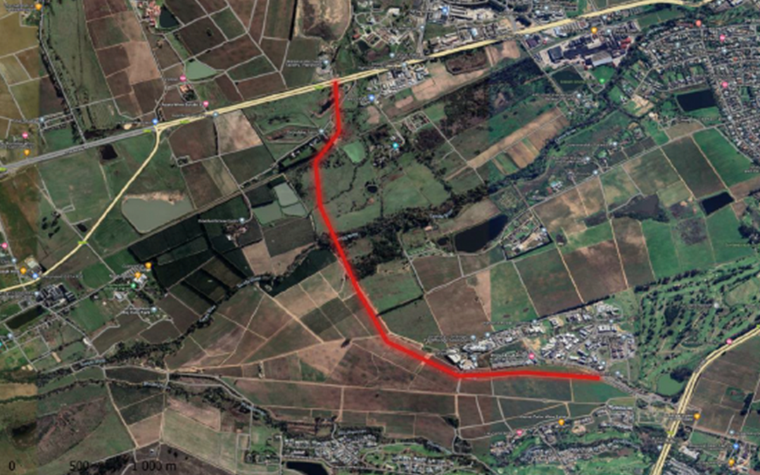
Guillaume Nel Environmental Consultants (GNEC), as independent environmental consultants and impact assessors, has been appointed by IX Engineers, on behalf of Stellenbosch Municipality (hereinafter referred to as the Applicant), to facilitate the Integrated Environmental Management (IEM) procedure for the proposed Development of the Adam Tas Link Road which will cross several properties, these include Farm No. 377, Street Parcel Re/9190, Portion 4 of Farm Fleurbaai No. 1040, The Remainder of Farm Troughend No. 284 and Portion 1 of Farm Troughend No. 284 and the Remainder of Farm No. 279 (hereinafter referred to as the “proposed site”). (Please refer to Figure 1-3).
According to the Stellenbosch Road Masterplan (WSP, 2018) the idea of a road to bypass Stellenbosch to the west of Stellenbosch originated 20 to 30 years ago. There was also the idea of an eastern bypass from Jamestown through Paradyskloof, Brandwacht/Dalsig area to intersect Van Riebeeck Street opposite Marais Street. This road would have provided an “eastern bypass” to link to the Helshoogte Road.
The implementation of this route is difficult, due to buildings of the Boland College that are located on the planned route. It was recently discovered that a route from the R44 from opposite the Techno Avenue-intersection, through Blaauwklippen farm along Wildebosch Road (through Paradyskloof and Brandwacht) and to the east of Dalsig, across Welgevallen and Coetzenburg to tie in opposite Marais Street is a proclaimed Provincial main road. It thus appears that this proclaimed main road was supposed to be the “eastern bypass” mentioned above.
In addition, it was determined that inbound volumes along the R44 (south of Technopark) have increased by approximately 13% from 2012 to 2019 to 3167 vehicles per hour (vph). As a consequence, long queues and delays are experienced on the R44 during the weekday AM peak.
Considering traffic at Technopark it is important to note that despite some local improvements over the years, the signalised intersection on the R44 experiences major capacity issues. The two conflicting movements are the high volume of right turning traffic into Technopark conflicting with the high volume of left turning traffic into Technopark and the northbound through traffic. The historic proposal for the upgrading of a portion of Techno Road to two lanes per direction to improve traffic flow near to the intersection with the R44 has been approved. A second access to Technopark has also been proposed, this road link forms part of the future Western Bypass and links Technopark with Adam Tas Road.
It is clear that the road network will not be able to supply the required capacity for the medium to long-term growth needs of Stellenbosch. This is very evident on the higher order Provincial roads. It is therefore acknowledged that some roads, particularly in the historic town area, may in future operate at or over capacity during peak periods (unless modal shift changes). It should also be noted that weekday AM and PM peak period traffic congestion will spread over a longer time (peak hour spreading) as a result of historic and present capacity problems.
In order to improve and accommodate increasing traffic, as well as be in line with the 2040 traffic assignment as explained in the Stellenbosch Road Masterplan (WSP, 2018), the Applicant is proposing to construct a link road between the existing roundabout located in Techno Avenue, which spans from the existing R44 roadway to the existing Adam Tas Road (R310) opposite the Material Recovery Recycling Facility entrance. The proposed development site is located within the Stellenbosch Municipal area of jurisdiction. The majority of the properties on which the link road will be constructed is used for agricultural purposes.
The proposed project will involve the route determination and construction of a new roadway of approximately 3.40 kilometres in length between the above-mentioned roadways. The road reserve to be registered will amount to approximately 40-55 metres in width however the proposed road will ultimately be approximately 25.4 – 34.2 metres wide.
It is important to note that the proposed development which is applied for in this application entails the proposed development of a road with the following dimensions: 3.40 kilometres in length and 10.50 – 12.20 metres wide. In addition, a bridge is proposed to cross the prevailing Eerste River. The bridge will be approximately 50 metres in length and 13.40 metres wide. A bridge will also be constructed over the existing railway line, located approximately 395 meters south of the existing Adam Tas Road.
Find the Project Proposal here